Listen to this blog
6 minutes
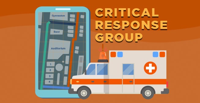
Raptor has teamed up with Critical Response Group, Inc. (CRG) to help first responders and school districts get on the same page. Digital mapping is a military communications technique that CRG has perfected to help schools give public safety professionals access to valuable site-specific information during an emergency. Through the use of digital mapping, school districts and first responders can adopt a common language that helps save valuable time during an active threat. On School Safety Today, a Raptor podcast, our host Joey Wahler sat down with Mike Rodgers, a U.S. Army veteran and Founder/CEO of CRG, to break down why digital mapping is a school safety best practice that every district should know about.
What is Digital Mapping and How Does It Work?
Digital mapping originated as a military communications technique for conducting night raids. These real-life situations force military personnel of different disciplines to work together in an unfamiliar environment. By creating easy-to-understand digital maps of their surroundings with labels in “plain-text language,” the U.S. military found that they could initiate a quicker response.
“The U.S. military, and specifically [war], has created a unique laboratory for us to solve complex problems overseas and bring [solutions] home,” said Rodgers. “We wanted to take what we learned overseas [and] use public safety professionals domestically to help us round it out.”
Rodgers, whose wife and two younger sisters are public school teachers, saw an opportunity to apply this technology to school safety and security. According to Rodgers, 80% of first responders’ radio communications during an emergency is about location.
Many first responders have never been to a particular school building before they are asked to respond to an emergency there, and their maps often do not contain the language used by school personnel to describe their location. According to Rodgers, this is “setting [first responders] up for failure.”
When an educator, for example, initiates an emergency call, the first responder may struggle to find their particular classroom on a building blueprint if it is not labeled appropriately. In an active threat situation, such as a school shooting, this delays the emergency response – and can result in more lives lost. As Wahler said, “in this situation, time is often life and death.”
“You’re going to this [unfamiliar] location on the most stressful day of your life, and every second matters,” said Rodgers. “We want to make sure we give [first responders] the data to drive accurate and educated decisions.”
By overlaying first responders’ digital maps with proprietary 2D graphics and site-specific labels, CRG allowed for more efficient communication between public safety officials and school personnel in an emergency situation.
“Our tenet is that it doesn’t matter your level of training, your jurisdiction, or your public safety discipline,” said Rodgers. “We want to create a common operating picture across the ecosystem. Our goal, at the end of the day, is to ensure that the responders have the data that they need to drive an efficient decision and make the safest decision possible.”
Why CRG Partnered with Raptor to Enhance School Safety
When consulting with first responders at home, Rodgers found that they were facing similar problems as the various U.S. military branches in finding a common language with school districts while responding to emergencies.
First responders’ mapping tools did not present imagery in the same way as schools’ building blueprints, and their software often used different file formats. Many blueprints were outdated and unreliable, and the floor plans were not labeled to match the actual nomenclature used by school staff to describe the facilities.
By partnering with Raptor, districts that use critical response graphics from CRG can easily integrate their digital maps into Raptor’s emergency management solution for more precise communication, enabling first responders or other key staff to know precisely where on campus the incident has occurred when an emergency response is initiated.
“Raptor is the best in class at understanding the needs of the school…and we are integrating our mapping data directly into their tool,” said Rodgers. “It’s an extremely simple fix to an incredibly complicated issue that we see [in school districts].”
Many school districts are eager to implement digital mapping technology into their safety plans. For example, Virginia’s Office of School Safety has partnered with CRG to offer schools grants for implementing digital mapping. Within the first two weeks of this program, about 25% of Virginia schools signed up for funding. Meanwhile in Wisconsin, Senate Bill 449 created a $2M grant program allowing schools to create critical interactive blueprints, or “maps” online, in lieu of physical copies that quickly become outdated. And, in June, under HB 6012, funding was set aside in Michigan for critical incident mapping to enhance security and communication.
“Unfortunately the terrible tragedies that we’ve seen across the country [are] forcing action [and] a different way to look at things,” said Rodgers. “We will be there to assist people as they’re looking at different options to put something in place to save a life. We’re not the end-all, be-all solution, but in my opinion, we’re a piece of…a much bigger solution…to set ourselves up for success across the country.”
To learn more about Raptor’s partnership with CRG to implement digital mapping into school districts nationwide, click here to listen to the full School Safety Today podcast episode with Mike Rodgers, Founder/CEO of CRG.
Related Resources
Guide to K-12 Emergency Management
Proven Strategies to Protect Your School
Learn More

Listen to this blog
6 minutes
Learn how Raptor and CRG can help make your schools safer
Featured video
Recent Webinar
Former Santa Fe Superintendent Shares Key Strategies for Coordinated Emergency Response
This is one of the most violent school years in...
Watch now